Thursday, 27 August 2015

Day 7 - Rest day in Bampton Grange

The first fine day in five, and we are taking a rest day.  We dry our boots and tent, and wash and dry our clothing.  Appallingly, the forecast for tomorrow is back to rain.

Fact for the day - In England, sheep are so fat that they cannot stand.  Instead they lie in one place in a paddock, and then graze the grass in a circle immediately around them.


Day 6 - Patterdale to Bampton Grange

The weather is more varied today, both drizzle and rain. Fiona is in wet boots for the 4th consequtive day, and I'm only a little better off.  We climb out of Paterdale and up into the hills again, then a long stretch across the tops.   Just before we begin our descent, Fiona does the numbers: we are booked to stay at our most expensive accomodation tonight, it is 1pm, and we may still have 7 hours of walking ahead of us; all of which means that she may barely get to enjoy the expensive room.  From the highest point in the day's walk Fiona takes off; accelerating downhill and taking the track in 4 metre strides.  I try to keep up, but after 10 minutes I've aggrevated an old knee injury, or to be more specific, two old knee injuries.  I hobble down the hill, then edge slowly along the side of Haweswater lake, to the village of Bampton Grange. 

Fiona contemplating the distance between herself and a hot bath.

The southern end of Haweswater lake

We decide to take a rest day tomorrow in Bampton Grange, to give my knees an opportunity to recover, and Fiona's feet a chance to dry out.

Distance Walked Today : 21km

Tuesday, 25 August 2015

Day 5 - Easedale to Patterdale

We have breakfast, then use almost the last of our cash to pay the bill for our B&B.  Fortunately Grasmere, only a kilometre away, is the first village that we've been past with an ATM; well, two ATMs actually.  Unfortunately, the first ATM is out of order, and the second will only accept UK issued bank cards.  We spend the very last of our money to catch a bus the 10km into Ambleside, restock on cash, then catch another bus back to Grasmere; all of which delays the start to our walking to 1pm.

Summer in the Lake Districts is on form, and it is raining again.  We head up into the hills, meeting no one.  Presumably it is too damn wet, and anyone else who is walking the Coast-to-Coast will be four hours ahead of us.

Fiona, soaking up summer in the Lake District

We have lunch, more sandwiches in the rain, just before the highest point on the day's walk; then cross a pass between two mountains and desend to a large tarn.  On the edge of this we stop for photos in the rain.


A minute later two figures appear out of the mist at the end of the lake.  One walks over and asks us if we know where we are.  I'm a bit incensed by this question, because I like to think that my wilderness navigation skills are not too bad, but I restrain myself and simply say "yes".  Then the conversation takes an unexpected turn, and he asks me if I could tell him where he is.  It turns out that they, a brother and sister, have just summited Britian's 3rd highest peak then become lost on the way down.  They are both wearing jeans, which brings to mind the old quote - "there is no such thing as bad weather, only inappropriate clothing".  The sister looks cold, and Fiona and I have got two packs full of warm clothing between us.  The sister accepts my gloves and a couple of chocolate biscuits.  They then follow us down to Patterdale, the destination for both walking parties.  

We reach Patterdale at 6pm.  Fiona and I are camping outside the YHA, in the rain again.  Fiona is now up to 3 days in sodden boots. My boots are a little more water proof so I'm doing a bit better. 

Distance walked today : 13km

Day 4 - Seatoller to Easedale

Damn, the weather forcast was wrong.  It's drizzling and there will be no chance to dry either boots or clothing today.  We pack down the tent, leave our gear for the pack carrying company to pick up, then walk back to the next village to get breakfast.  Then off for a six hour walk across sodden boggy hills in the drizzle.  Don't get me wrong, they look great, it's just that they are also a boggy abyss.  Who would have guessed that the Lake Districts would be so wet?

"In England's green and soggy land..."

Lunch in the lee of another rock, then on across the hill tops, again encountering a staggering number of Brits who seem to be out for walks on mountains, in the rain, with inadequate clothing, and evening settling in.  It is beyond us how they avoid gettng into trouble.  

Fiona laughing in the face of adversity; well, two days of sodden boots and damp clothing

We stay in a very pleasant B&B, and hang our sodden gear over every fitting in our tiny room.  

Distance Walked Today : 16km


Sunday, 23 August 2015

Day 3 - Ennerdale Water to Seatoller

After another full English breakfast (for me, Fiona was more sensible) we decide to take the high route out of the Ennerdale Valley, which means starting the day with a 650m climb.  Great views over the Lakes District from the top of the range.


We push our walking along.  It is overcast now, we are being buffeted by the wind, and rain is forcast to start around 2pm.  Descending along the ridgeline we meet all sorts of people: couples, families walking with kids, people walking dogs, solo photographers; one thing that you can say for the locals, they don't let a bad weather forcast stop them getting out into the mountains.  We are also surprised that many of the people that we see are not wearing any specialised outdoors clothing, just the same gear that they would wear into town. 

Fiona descending the ridgeline, with un-needed sunhat in tow.

We manage to get off the high ground as the rain arrives at 2:30pm, right on schedule. We huddle in the lee of a large rock, eating soggy sandwhiches purchased (dry) from the YHA earlier in the day.  A group of very wet walkers turn up.  They have come over the low route up the valley.  Then more walkers turn up, then more.  Soon there are twenty plus people on the hillside.  We plod on in the middle of the convoy.  Damn, the person at the front has gone the wrong way, taking us all on a longer route.  Lesson for today - always do your own navigation.  We arrive at a small village with a cafe and order hot soup; then head on to complete the final 4km for the day.  Most of the other walkers have given up, and are standing outside the cafe waiting for a bus.  

We reach Seatoller at 6pm, having walked 20km, and pitch our tent in the rain.  More bad news, there is no place to buy food in the village.  We walk an additional 2km to the next village for a place to eat.  After dinner we walk back another 2km in the dark and rain.  We crawl into our tiny tent at 9:30pm, knowing that we will be putting on soaking wet walking gear the next morning.  We've definitely had better days.  At least the forcast is better for tommorrow; maybe things will dry out during the day.

Distance Wallked Today : 24km


Day 2 - Cleator to Ennerdale Water

We stock up on biscuits and chocolate bars at the local store, then tackle the 300m climb, through forests and over farm land, to the top of Dent Hill.  The weather is clear, and we have good views out over the countryside to the Isle of Man, Scotland, and the picturesque Sellafield Nuclear Reactor.

View looking east (the direction in which we are heading) from Dent Hill

Then down into a Wind-in-the-willows-esque valley.


We have lunch at a country pub in the village of Ennerdale Bridge, then make our way along the side of heather clad Ennerdale Water. 


The Ennerdale valley is apparentlly the least populated in England, and the definition of serenity; all of which make it the perfect place for the RAF to use for training fighter pilots in low altitude flying.  Unfortunately I didn't get any photos of the jets.  By the time we saw them hurtling overhead, they were gone again.

We spent the night at the Ennerdale Water YHA, where I rediscovered why I hate dormitories.

Distance walked today : 18km


Day 1 - St Bees to Cleator

I have a full English breakfast to start the day.  To help preserve my trim post Lycian Way physique, ruined only by a month of extreme tapas eating in Spain, I skip the toast and stick to sausages, bacon, eggs, etc.  The plan is to have lunch at midday at a pub in Sandwith that is mentioned in the Coast to Coast guidebook. We start the day with a 700m walk from St Bees down to the beach, pick up the traditional peeble (to be deposited on the opposite coast at the end of the walk) and get underway in fine weather.  The first part of the Coast to Coast is a walk along cliff tops.  It is prime bird watching territory, and with our newly purchased binoculars we manage to identify: gulls, gulls, and more gulls.

Not Broadchurch

We reach Sandwith at 1pm ready for a big lunch, but the pub that the guidebook describes as "open 7 days" is closed on Mondays, and of course it is a Monday, and there is no where else in the village to buy any food.  

After 10 minutes spent licking a wooden picnic table for nutrition, we decide to press onto the next village where the guidebook informs us a bakery and cafe await.  Fifty minutes later we reach the next village.  The bakery is shut and the cafe has gone out of business.  My plan is to catch and spit roast a cat, but Fiona convinces me to press onto the next village.  It is 4pm before we find anywhere selling food.  Not the best of starts to our walk.

Lesson's learnt today:

1) Carry some food with you, even if you think that you will have numerous dining options along the way

2) Don't trust the guidebook

3) In Britain - dogs grow in planter boxes


Distance walked today - about 15km

Monday, 17 August 2015

Day 0

After two months in Turkey walking the Lycian Way, and a month in Spain eating tapas, we have relocated to Britain; meaning that day time temperatures have gone from 42 degrees


to something in the 15 to 19 range.


Over a few days we make our way to St Bees, the start of the Coast to Coast walk.  Three hundred kilometres from the Irish Sea, across three national parks, to the North Sea.  It is now mid August. We will be walking a little after the peak of summer, but the school summer holidays start in mid-July in England, and we hope that by starting a month later we can avoid the peak season crowds.

As preparation we've walked the Lycian Way; 500km up and down mountains in Turkey.  Our instinct is that the Lycian Way should be plenty of preparation for the Coast to Coast, but we completely under-estimated the Lycian Way and are determined to not make the same mistake twice; so we are trying to avoid making too many assumptions with regard to our levels of fitness for the Coast to Coast.  The Coast to Coast typically takes between 14 and 19 days of walking.  Or goal is to enjoy the walk as much as possible, rather than complete it as quickly as possible.  To this end we plan on starting out slow, and then seeing how much scope there is to speed up.  Fiona's back is a bit twingy, but this is the only injury that we are starting with.

We've got basically the same gear that we used in Turkey, except that I've replaced my boots after the Lycian Way destroyed the previous pair, and we've swapped the lightweight raingear that we had in Turkey for some much sturdier coats.

An important difference between the Lycian Way and the Coast to Coast is that on the former we had to carry all of our gear on our backs (31kg between us on a bad day), but for the Coast to Coast we are utilising the services of a company that picks up our gear in the morning and drops it at our next destination in the afternoon.  This means that we are only carrying 10kg between us during the day.  The only downside of utilising the services of the pack carrying company is that it does largely preclude  the option of wild/freedom camping (which we so enjoyed on the Lycian Way).

We've got to St Bees without any great drama.  The biggest thing that went wrong was that we were relying on a bus to get us from Whitehaven to St Bees, as described in the Coast to Coast guide book, but when we got to Whitehaven we discovered that the bus service had been decommissioned; so we caught a taxi.

We've researched which mobile phone networks have the best coverage on the Coast to Coast route, and purchased a British SIM card for each of our phones.  We've opted for two different networks to maximise the chance that one of us will have coverage.  

Anyway, we are now in St Bees and ready to start the Coast to Coast tomorrow.  In high season people are advised to book all of their Coast to Coast accommodation in advance.  We feel that this would constrain the timing of our walk too much, so we have only booked the first 4 days in advance.  It will be interesting to see how booking accomodation on the go works out.

Final preparations - carbo loading with cheese cake and sticky date pudding - the desserts of champions.


Sunday, 16 August 2015

11. Segura de al Sieraa

From Cordoba we moved east to Segura de la Sierra (red flag) below. We chose Segura for access to walking tracks, wanting to keep our fitness up and wear in Kim’s boots before the Coast to Coast walk in England.  


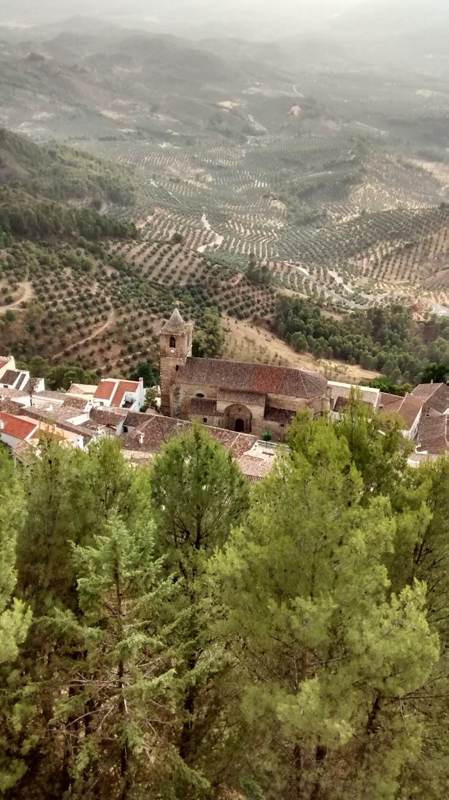
We discovered that Segura was a cute village positioned a steep hill surrounded by lots of cliff faces, with a big castle perched right on the top. When we located our accommodation among the tight, twisty, narrow streets, we found we were right below the castle grounds.


Segura de la Sierra had lots of interesting sites to check, and despite the 40’C heat we kept a pattern of walking in the morning and visiting sites at about 6pm when it was cooler prior to our late Spanish dinner. The castle had been extensively restored and presented for tourists. Additionally there were Moorish baths, a Jesuit church and various historic gates and walls to emphasize the long history of the town.

On the last day, some
cloud
rolled in
preceding a thunder storm

To our delight, several Spanish ibex (think mountain goat) were grazing each morning and evening on the grassy area between our accommodation and the castle, unconcerned about humans passing by.


The downside of Segura was accommodation with tissue thin walls, so we were short on decent sleep. This was accentuated by the hot night-time temperatures. Our hosts told us that the average temperate this summer was 10’C higher than last summer – although last summer was slightly cooler than average. When locals have enough English to interact with us, they complain about the relentlessly hot weather; it seems they are not enjoying it any more than we are. In Segura we were out of tourist territory and everything closed for siesta between 2 and 7 pm. So if we forgot to buy food before 2pm, we had to improvise from existing supplies or go hungry. All in a day’s tourist work.

Wednesday, 5 August 2015

10. Cordoba and the Mezquita

Cordoba's earliest inhabitants pre-date the Bronze Age, so things have been happening here for a fair while. In Roman times, Cordoba was the capital of a Roman province and home to Roman philosophers such as Seneca. The ruins of a Roman temple were just round the corner from our abode. Ancient churches are on almost every street, but the most famous site of all is the Mezquita, the Mosque-Cathedral of Cordoba, and it was high on our list of places to visit. It's thought that the first place of prayer built on the Mezquita site was an early temple. It's certain that a Christian church was erected on the site by the Visigoths in the C7th.  Some remnant pieces of this building are on display, the artistry of which made Kim comment that the Visigoths were obviously much less barbarian than we assume, and clearly needed a better PR team.

The Muslim Moors conquered the area in 711 AD, and Visigoth church was first divided into Muslim and Christian halves; an arrangement that lasted for over 70 years until the Christian half was purchased by the ruling Muslim Caliph of the time. In 784 AD, work to build the Great Mosque (the Mezquita) on the site began, and improvements continued for two centuries.


Cordoba is thought to have been the biggest city in the world by 1000 AD, with a population of a quarter of a million people, plus numerous libraries,  universities and medical schools (which established some medical techniques that were only superseded in the C20th). As the most prosperous city of Europe, it outshone Byzantium and Baghdad. According to the Rough Guide to Andalusia, the Mezquita had an original copy of the Koran and as a place of pilgrimage, it ranked fourth in sanctity after Mecca, Medina and Jerusalem. Eventually however, things declined and, in 1236, the Reconquista saw Cordoba reclaimed by Christians from the North.  The Mezquita was turned into a Cathedral, and later an apse placed in the middle. Happily the orange tree courtyard was retained (Kim and I are now official fans of orange tree courtyards); as were other features intrinsic to the building like the great halls of pillars.


Recently, Muslims across Spain have lobbied the Roman Catholic Church to allow them to pray in the complex, with the Islamic Council of Spain lodging a formal request with the Vatican. However, (according to Wikipedia) Spanish church authorities and the Vatican have opposed this move.

The Mihrab or prayer niche. It survived unchanged after being bricked up
following the Christian Reconquista, 1236, and only rediscovered in the C19th. 


The Mezquita stands beside a restored Roman bridge which spans the Guadalquivir River. At the other end of the bridge is the Tower of Calahorra. The very well presented historic material in the Tower has a strong pluralist theme, including highlighting quotes from historically prominent Jewish, Muslim and Christian leaders/thinkers connected to local events. Most of the quotes point up religious tolerance and inclusion, plus the audio guide has other pithy lines, which are not referenced, such as: the centre of God is everywhere and the circumference is nowhere.


Reading the history of the Mezquita had made an impression on me. Also, I had been keen to see Moorish architecture in Andalusia, and was a bit disappointed by the lack of it prior to Cordoba. Some of the most important examples are retained at the Mezquita. Our visit to the Mezquita site, the current Catholic Cathedral, had the usual context of tourists posing for selfies, and the cleaner with a mop entering the gates which lock off the current worship area when not in use for Mass. Plus, there were no information boards about Mezquita's history, which I thought was sad. So it was easy to miss a whisper of immense presence and story. Perhaps the focus in this blog is my response.


The Andalusian Sufi mystic and poet, Ibn Arabi (1165 - 1240), born near Cordoba, wrote

My heart has become capable of every form:
it is a pasture for gazelles and a convent for Christian monks,
a temple for idols and the pilgrim's Kaa'ba,
the tables of the Torah and the scrolls of the Quran.

I follow the religion of Love:
whichever way Love's camels take,
that is my belief, the faith I keep.